


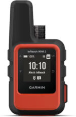


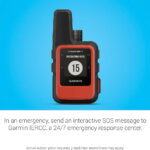
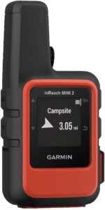


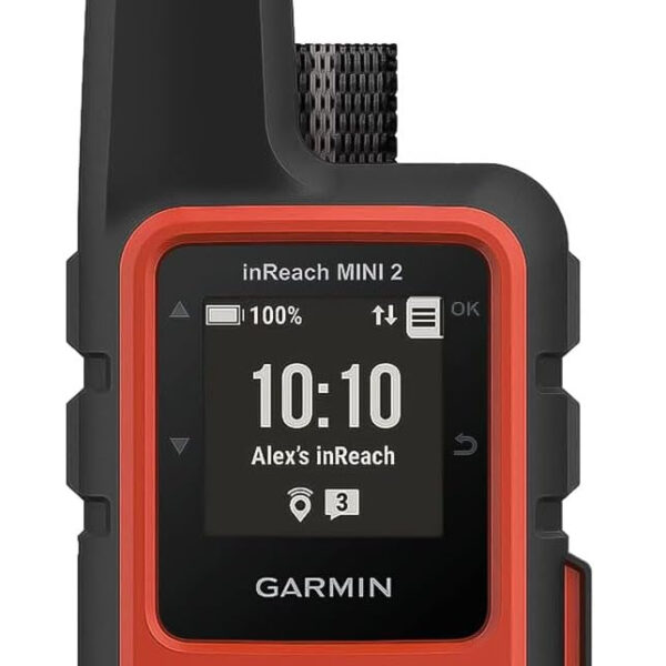
Garmin inReach Mini 2, Lightweight and Compact Satellite Communicator, Hiking Handheld, Orange – 010-02602-00
The Garmin inReach Mini 2 is the essential, lightweight satellite communicator for global hiking, backpacking, and off-grid adventures. This compact, orange handheld device ensures your safety anywhere on Earth by providing two-way satellite messaging and a critical, 24/7 interactive SOS function, acting as your reliable lifeline beyond cell coverage.
- Global two-way satellite messaging for contact anywhere.
- Interactive SOS monitoring for coordinating rescue efforts.
- Extended 14-day battery life for long excursions.
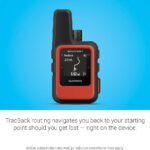
- TracBack routing and digital compass navigation.
£314.99
In stock
In stock
Manufacture Warranty

Fast & Secure Shipping

Free 30-Day Returns

Authentic Branded Product


Payment Methods:
Description
Garmin inReach Mini 2: Essential Lightweight Satellite Communicator for Global Hiking & Off-Grid Adventures (Orange)
Ensure your safety and maintain connection anywhere on Earth with the ultralight, compact Garmin inReach Mini 2 satellite communicator. Perfect for serious hikers, backpackers, and outdoor professionals, this essential handheld device provides two-way text messaging and a critical interactive SOS function, offering peace of mind when you venture beyond mobile coverage. Featuring an incredible 14-day battery life (in 10-minute tracking mode), TracBack routing, and digital compass navigation, the inReach Mini 2 is your reliable lifeline for navigating and communicating from the world’s most remote locations. Sync seamlessly with the Garmin Explore app for advanced trip planning and sharing your real-time location with family and rescue teams.
Key Features
- Global Two-Way Satellite Messaging: Send and receive messages anywhere, ensuring contact even without cell service.
- Interactive SOS: Trigger a distress signal 24/7 with professional monitoring to coordinate rescue efforts globally (Active satellite subscription required).
- TracBack Navigation: Navigate reliably back to your starting point using the device’s precise routing feature.
- Extended Battery Life: Enjoy up to 14 days of continuous operation in 10-minute tracking mode.
- Digital Compass: Get accurate heading information, even when stationary.
- Water-Resistant Design: Built to withstand rugged outdoor environments.
- Sync with Garmin Explore: Plan trips, access topographical maps, and manage waypoints via your compatible smartphone.
- Pairing Capability: Connect with compatible Garmin wearables and handhelds to send/receive messages remotely.
Important Information
- Active satellite subscription is required for two-way messaging and SOS features.
- Check local regulations, as some jurisdictions prohibit or regulate the use of satellite communication devices.
- Included components: inReach Mini 2, USB cable, carabiner clip, and documentation.
- Connectivity technology: Bluetooth and USB.
- Screen size: 1.27 Inches.
Why Choose Think Assemble
- Quality Assurance: Every Garmin inReach Mini 2 is inspected to ensure peak performance before shipping.
- Fast Shipping: Get your vital communication gear quickly with our expedited fulfillment process.
- Dedicated Support: Our expert team is ready to assist with setup and subscription guidance.
Specification
Overview
| Weight | 99 g |
|---|---|
| Dimensions | 5.18 × 9.91 × 2.62 cm |
| Department |
unisex-adult |
| Manufacturer |
Garmin |
| Item model number |
010-02602-00 |
| Product Dimensions |
5.18 x 9.91 x 2.62 cm; 99 g |
| Guaranteed software updates until |
unknown |
Customer Reviews
26 reviews for Garmin inReach Mini 2, Lightweight and Compact Satellite Communicator, Hiking Handheld, Orange – 010-02602-00
Clear filtersOnly logged in customers who have purchased this product may leave a review.
Related Products

In stock


In stock
In stock
In stock
RH –
Great items if you are exploring out on your own
Tumour killer –
Used this while climbing Mount Kilimanjaro what an absolute game changer this was.I was the only person in my group, including guides that could get up-to-date weather reports as and when needed. The map share function was absolutely spot on and being able to send and receive satellite messages to friends and family back home, was a much needed morale boost. I really can’t emphasise enough just how great this thing is! The only slight downside is the activation subscription cost. You need to pay to activate then you need to pay a monthly subscription upfront.
Genghis McCann –
If you’re looking at this product then you most likely know all about it so no point in me repeating all of its features. When I purchased mine, the most basic monthly subscription service cost about £13. A few months later it was reduced to around £8 per month which I feel is more reasonable. I take this with me every time I’m out on the hills and it provides a reassuring level of peace of mind. It is possible to stop and start the subscription when you think you won’t be needing it, but I always forget to do so.
Mr David Carr –
Invaluable when you really need it but seems like a waste of money most of the time. The subscription system has now changed so not sure how much longer I will keep it as my iPhone now has satellite compatibility. I use it when sailing and motorcycling abroad , invaluable whilst sailing.
A. J. Gauld –
I bought this because for £50 more than the Messenger it provided navigation features and since I don;t have a GPS device(other than my phone) I thought it would provide an extra level of safety. In practice the navigation features were so awkward to use that I just stuck with my phone, so I wish I’d just got the Messenger and saved my money.As a messenger it performed near faultlessly – one check-in message did go missing but all others reached my wife. About 50% of them had no location data because the mini couldn’t get a fix. I. used both the Mini and the Garmin messenger app to send (and receive one) messages and the switch between phone and Mini was seamless. And the transmission switch using the phone from cell to satellite also worked as advertised.The software UI is awful. It’s completely non-logical with navigation and tracking features randomly scattered around the menus. I’m sure you get used to it eventually but for a beginner it is dreadful. Also, there is no clear indication of whether a message is being sent/has been sent/failed. You press the button and just wait and trust that it will go through. The Garmin Explore navigation app is the worst I’ve used and made worse by the strange mix of terms used – tracks, routes, courses… Some work with some devices but not others. It’s confusing and surely unnecessary. In the end, it was easiest to use (any) other app and export a GPX file and then import it to the Mini.I didn’t have to use the SOS, and hopefully never will, but it was reassuring to know it was there.I also bought a cheap holder/attachment for my rucksack strap that helped with usage on trail. Having it dangle via the supplied karabiner didn’t feel safe.EDIT: After 6 months of use I have figured out the explore app and it is usable. The actual navigation on the in reach works well most of the time and I have used it on several trails now. I still treat it as a backup to the phone app which obviously has a bigger screen and so shows more context. But the in reach has been useful confirmation of which side of a fork to take for example. Enough that I am now glad I paid extra for the mini over the messenger.
Jennie Cunningham –
I bought this for my son who is out trecking in the mountains a lot and to ease my worrying about him. It’s a very good product. It shows a clear thick blue line on his tracking route and shows a blue dot when it’s updated his location every fifteen minutes or so. It gives time, speed of walking and latitude/longitude. So far it’s been very reliable. occasionally if my internet has a poor signal then it won’t show up. it seems to be able to cope with remote locations. I would recommend.
Paul Gacek –
I had the original “large” inReach that lasted 10+ years and travelled many miles by plane, train, Jeep and foot.Its clearly a personal choice but if off solo or somewhere where cell coverage in spotty or non existent then this device plus its subscription to me is table stakes. If something goes wrong and you’re looking at the worst case scenario then this gizmo might make a serious difference. It’s so small, usable via its diminutive little screen and while not necessary can be paired with a phone. My subscription includes the every 10 minute location ping to the sat net which I turn on diligently for serious hikes and little local noddy ones. My loved ones like this gizmo too!! Photo is the old “dead one”, new one much smaller.
Raz –
Very good
Jean Kraft –
Reliable, reasonable price
It is a great device, i always take it for adventures, compact, reliable
Mme E. Knaust-lyster –
Contact and rescue from anywhere in the world at the touch of a button !
Essential piece of kit for anyone that spends a lot of time in the outdoors.
Jesús G. –
Buen producto
Excelente, yo lo uso para que mi familia me ubique cuando salgo en la moto, hay que comprar un paquete de emergencia, bajar una app de Garmin, nada difícil.
Mikael Gordon –
Ingen riktig karta – annars bra
Innan jag köpte denna satellit-enhet så lästa jag noggrant igenom användarmanualen. Det fanns flertalet instruktioner om att använda kartan. Det blev en stor besvikelse när det visar sig att denna lilla enhet INTE har någon karta. Det är endast waypoints och din egen position som visas på en svart skärm utan bakgrund. Efter kontakt med Garmin så fick jag beskedet att byta till en Gpsmap 67i med både satellitfunktioner och karta. Uppenbarligen är maskinöversatta manualer inte så tillförlitliga – inte heller framgick det att någon riktig karta inte finns eller kan installeras.
John –
Great product but poor support
Excellent delivery from supplier. Garmin lets this product down. As a last step in emergency recovery notification I feel that the support in setting this product up and functioning was severely lacking. I was left feeling doubtful that in an emergency it would function correctly. Garmins instruction were of a general nature written for all its products and as a safety device I think it requires dedicated instructions. It took several days hunting through web sites and FAQ’s to get the system functioning to my expectations. I took on the basic plan and used in excess of my allocated messages to get the system sorted.
RH –
Great items if you are exploring out on your own
Tumour killer –
Used this while climbing Mount Kilimanjaro what an absolute game changer this was.I was the only person in my group, including guides that could get up-to-date weather reports as and when needed. The map share function was absolutely spot on and being able to send and receive satellite messages to friends and family back home, was a much needed morale boost. I really can’t emphasise enough just how great this thing is! The only slight downside is the activation subscription cost. You need to pay to activate then you need to pay a monthly subscription upfront.
Genghis McCann –
If you’re looking at this product then you most likely know all about it so no point in me repeating all of its features. When I purchased mine, the most basic monthly subscription service cost about £13. A few months later it was reduced to around £8 per month which I feel is more reasonable. I take this with me every time I’m out on the hills and it provides a reassuring level of peace of mind. It is possible to stop and start the subscription when you think you won’t be needing it, but I always forget to do so.
Mr David Carr –
Invaluable when you really need it but seems like a waste of money most of the time. The subscription system has now changed so not sure how much longer I will keep it as my iPhone now has satellite compatibility. I use it when sailing and motorcycling abroad , invaluable whilst sailing.
A. J. Gauld –
I bought this because for £50 more than the Messenger it provided navigation features and since I don;t have a GPS device(other than my phone) I thought it would provide an extra level of safety. In practice the navigation features were so awkward to use that I just stuck with my phone, so I wish I’d just got the Messenger and saved my money.As a messenger it performed near faultlessly – one check-in message did go missing but all others reached my wife. About 50% of them had no location data because the mini couldn’t get a fix. I. used both the Mini and the Garmin messenger app to send (and receive one) messages and the switch between phone and Mini was seamless. And the transmission switch using the phone from cell to satellite also worked as advertised.The software UI is awful. It’s completely non-logical with navigation and tracking features randomly scattered around the menus. I’m sure you get used to it eventually but for a beginner it is dreadful. Also, there is no clear indication of whether a message is being sent/has been sent/failed. You press the button and just wait and trust that it will go through. The Garmin Explore navigation app is the worst I’ve used and made worse by the strange mix of terms used – tracks, routes, courses… Some work with some devices but not others. It’s confusing and surely unnecessary. In the end, it was easiest to use (any) other app and export a GPX file and then import it to the Mini.I didn’t have to use the SOS, and hopefully never will, but it was reassuring to know it was there.I also bought a cheap holder/attachment for my rucksack strap that helped with usage on trail. Having it dangle via the supplied karabiner didn’t feel safe.EDIT: After 6 months of use I have figured out the explore app and it is usable. The actual navigation on the in reach works well most of the time and I have used it on several trails now. I still treat it as a backup to the phone app which obviously has a bigger screen and so shows more context. But the in reach has been useful confirmation of which side of a fork to take for example. Enough that I am now glad I paid extra for the mini over the messenger.
Jennie Cunningham –
I bought this for my son who is out trecking in the mountains a lot and to ease my worrying about him. It’s a very good product. It shows a clear thick blue line on his tracking route and shows a blue dot when it’s updated his location every fifteen minutes or so. It gives time, speed of walking and latitude/longitude. So far it’s been very reliable. occasionally if my internet has a poor signal then it won’t show up. it seems to be able to cope with remote locations. I would recommend.
Paul Gacek –
I had the original “large” inReach that lasted 10+ years and travelled many miles by plane, train, Jeep and foot.Its clearly a personal choice but if off solo or somewhere where cell coverage in spotty or non existent then this device plus its subscription to me is table stakes. If something goes wrong and you’re looking at the worst case scenario then this gizmo might make a serious difference. It’s so small, usable via its diminutive little screen and while not necessary can be paired with a phone. My subscription includes the every 10 minute location ping to the sat net which I turn on diligently for serious hikes and little local noddy ones. My loved ones like this gizmo too!! Photo is the old “dead one”, new one much smaller.